


Home -> Stamps -> 2021 -> SEPAC Historic Maps -> First Day Cover
We also recommend:
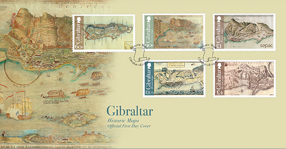
Historic Maps
Historic Maps (view technical specs)
Some exquisite examples of the historical cartography on display at the Gibraltar National Archives have been featured as stamps. These beautifully detailed maps display the city and fortifications of Gibraltar whilst also giving us an insight into the 13th and the 14th ‘Great Siege’ of Gibraltar. The map on the £1.15 stamp from 1726, is titled ‘New plan of the Garrison of Gibraltar with its fortifications’. It features an ‘Explanation’ index with sites such as ‘the Gate leading to Spain’; ‘Willis’s Battery 463 feet higher than high water mark’; ‘The Wall of Charles 5th’; ‘The new Mole’ and other landmarks of importance. Not long after this map was created Gibraltar endured its 13th siege in 1727. King Philip V of Spain felt that he had been forced by Louis XIV to sign the treaty of Utrecht ceding Gibraltar to Great Britain. Spain was determined to regain Gibraltar. The 13th siege began on 22 February when the British fired on a party of Spanish workers in the neutral territory north of the Rock. From then on, the Spanish attempted to build batteries on the isthmus with which to bombard British batteries and the city walls, while the British attempted to halt Spanish progress. By 24th March, the Spanish had established batteries within range of the British defences and began a 10-day bombardment, inflicting considerable damage which the British struggled to repair. By the 20th May, the Spanish supply chain could not keep up with the demands of the bombardment while the British were almost constantly able to resupply by sea. The Spanish offered a truce on 23rd June, which was signed the next day. The map on the £4 stamp is a French map of Gibraltar also created during the 13th Siege. This map is particularly fascinating as it depicts firing lines from the Spanish batteries and the British defences. The top left section depicts two ships attacking Spanish lines noting ‘English ships detach from Vice Admiral Wager’s squadron, firing on the Spaniards during their attacks’. Wager was with the fleet under Sir George Rooke that captured Gibraltar in 1704.
The map on the 90p stamp depicts a French map created during the 14th siege, the longest and most famous of Gibraltar’s sieges, known as The Great Siege of Gibraltar. The American War of Independence broke out in 1775, and in 1779, Spain allied with France and declared war on Britain, the primary ambition of which being to recover Gibraltar. Bearing in mind the futility of previous sieges in which Gibraltar had been blockaded only by land, the Spanish launched a combined land and sea blockade in an attempt to starve the garrison into surrender. They bribed the sultan of Morocco into severing trade with Gibraltar and built booms to prevent ships landing supplies, while simultaneously blockading the isthmus with over 13,000 men, where work began on rebuilding the batteries from the previous siege 50 years earlier. From the summer of 1780, Spanish forces attempted to bombard Gibraltar with fire ships and gunboats, while the British attempted to devise ways of frustrating these attacks as well as bombarding the Spanish camp with the few cannon that could reach. The Spanish bombardment continued throughout the siege, though slackening at times, but the naval blockade was intermittent, meaning that merchants were able to land and sell supplies to the garrison, preventing it from being starved into submission. The merchants also conveyed those civilians who could afford it away from the Rock, and so the civilian population gradually declined. The siege concluded after Britain ceded East and West Florida and Menorca to Spain in exchange for Gibraltar in lengthy negotiations facilitated by France. The map on the £1 stamp is a 19th Century map published on 1 Dec 1823 by R.H. Laurie, Map & Chart feller of No. 53 Fleet Street in London with the title of ‘A plan of the town and fortifications of Gibraltar’. The map shows the ‘Garrison hospital’, the ‘Grand Barracks’, the ‘Navy Hospital’, the ‘New Magazine’ and the ‘Powder Magazine’ reinforcing the fact Gibraltar was first and foremost a military fortress even though by the end of the 19th century, the ‘Gibraltarians’ were given an official identity for the first time. Of note, it was in the 1830’s that Gibraltar-born residents began to outnumber foreign-born. By 1891 nearly 75% of the population of 19,011 people were Gibraltar-born. The map on the 60p stamp is small in size but beautifully coloured and clearly labelled. It was published by William Hughes, cartographer, engraver, lithographer, printer and publisher active in London during the middle part of the 19th century. In this map was can see locations for the famous horse ‘Race Course’, a ‘Temporary Village’; ‘Catalan Bay’; the burial grounds that are still in use today, ‘South Barracks’ and ‘Rosia Bay’ where legend has it Nelson’s body was brought back to, his body preserved in a cask filled with brandy before being take back to England.
Technical Specs
| Design: | Stephen Perera |
| Illustration / Photography: | Stephen Perera |
| Printer: | Bpost Security Printers |
| Process: | Offset Lithography |
| Colours: | 4 colours |
| Stamp size: | 50 x 30mm |
| Issue date: | 2021-09-08 |
| Stamp Values: | 60p, 90p, £1, £1.15, £4 |